Emergency managers now use dashboards to summarize much of what an incident’s response and recovery work entails along the lines of community-based impacts through the Federal Emergency Management Agency’s (FEMA) Community Lifelines. FEMA utilizes these lifelines as an information-gathering tool to quickly describe to agency administrators and leaders the scale and scope of an incident. Those metrics can drive the creation of incident objectives and provide an overview of the situation as the incident expands and contracts. This process is similar to using an ICS 209 Incident Status Summary Form but does not generate the same level of detail. FEMA notes that the status of each lifeline can be determined by reviewing situational reports, such as the ICS 209s, and communicating with partners and stakeholders in the public, private, and non-profit sectors.
As of June 15, 2024, the Dali has been refloated, and the last major pieces of the steel bridge truss have been removed from the Patapsco River. The deepest channel – the Fort McHenry Federal Channel – has been restored to the full 700-foot width and 50-foot depth, allowing all commercial and military vessels to safely travel into and out of the Port of Baltimore.
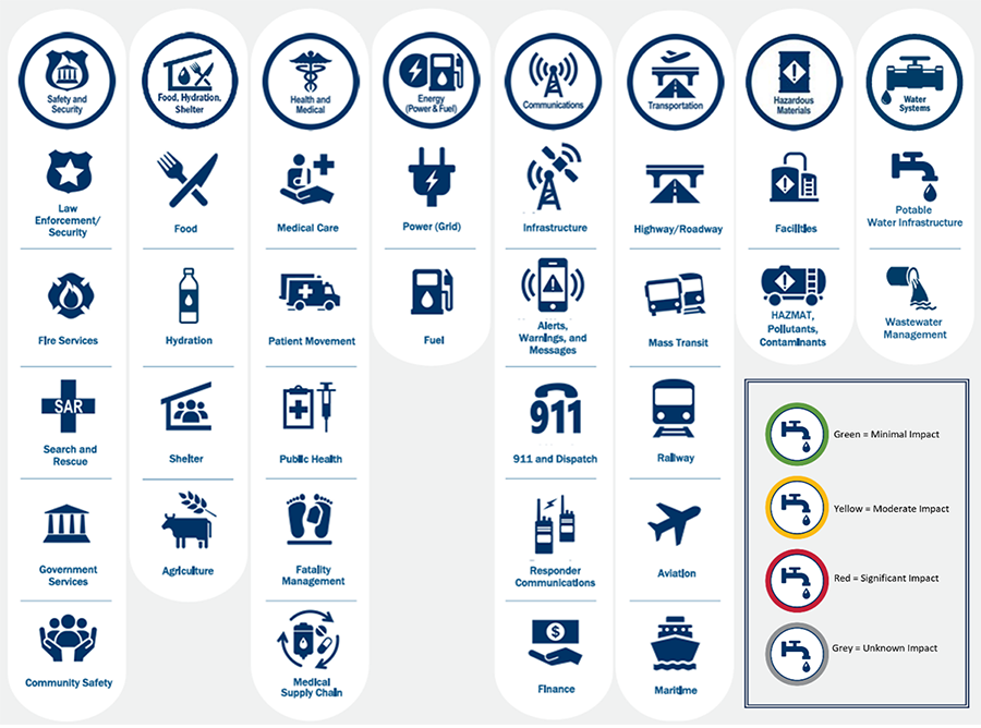
This article proposes another way to quantify the total current state of response and recovery progress conducted for the Key Bridge collapse by the unified command and local, county, and state governments. The current version of the FEMA Community Lifelines has eight major distinct elements: Safety and Security; Food, Hydration, Shelter; Health and Medical; Energy (Power & Fuel); Communications; Transportation; Hazardous Materials; and Water Systems.
One of the features of the Community Lifelines dashboard is a traffic-light-type color-coding of current adverse impact status: green indicates minimal impact, yellow is moderate impact, and red is significant impact. In addition, grey indicates unknown impact, and blue is for administrative purposes such as presentations and briefings (see Figure 1). The following sections describe the author’s unofficial analysis of the Community Lifelines dashboard approach and assignment of these colors, utilizing the real-world example of the Key Bridge collapse.

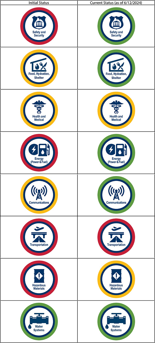
This lifeline covers law enforcement, security, fire service, search and rescue, government service, and community safety. Initially, when the bridge collapsed, there were additional response and recovery resources needed for law enforcement, security, and search and rescue. In addition, there were major impacts on critical infrastructure for this lifeline beyond the loss of the workers and the bridge itself. Port security was impacted, as the debris initially blocked the waterways to Hawkins Point and the USCG capabilities based there. For first responders, the Key Bridge offered a much shorter route to some of the neighborhoods and hospitals located on either end of the bridge. This lifeline may have started out red while the bridge roadways were being closed and massive first responder resources were engaged but could now be categorized as green, as mobile safety and security assets can be repositioned.
This lifeline has food, hydration, shelter, and agriculture associated with it. Initially, with major warehouse operations in and around the port, there were some food and agricultural impacts, which were counteracted via public-private partnerships. While there was moderate or yellow impacts initially, these have since stabilized relative to this Community Lifeline. So, this would now be green.
This lifeline covers medical care, public health, patient movement, medical supply chain, and fatality management. The six workers who perished were recovered over a multi-week period that did not overwhelm responders. The two survivors from the bridge collapse were the only ones who required health and medical treatment. While divers were in the water, this lifeline might have reached a yellow level to emphasize the significant health risks undertaken, but now that any work in the water is crane-based debris salvage only, one might consider revising this Community Lifeline as green. However, viewing this lifeline from a community-based impact, with ongoing increased response times for emergency medical services traveling to fixed-location hospitals and with the loss of the bridge, it should remain yellow.
This lifeline has power grid and fuel elements associated with it, with a natural gas pipeline running directly under the bridge. Initially, there was a concern that it was potentially compromised by the bridge collapse. Unified command worked with the utility company (Baltimore Gas and Electric, BGE) to make inert the pipeline by depressurizing it and removing any gas flow during the response operations. The public is not impacted by this gas pipeline shutdown, as there are redundancies in BGE’s distribution system, and this private utility will coordinate with regulators and other governmental officials to safely restore capability when authorized. Coal supplies to India from the Curtis Bay Coal Piers and the Baltimore Marine Terminal were also impacted while the port was closed. Restoring this maritime supply chain – the 9th largest port in the U.S. – is critical to “the U.S. economy, national security, and resilience.” With the bridge debris removed and maritime traffic resuming operations, this lifeline started out as red and is now green.
This lifeline covers infrastructure, responder communications, alerts, warnings, messages, finance, 911, and dispatch. On April 16, 2024, Region 3 of the Information Technology Disaster Resource Center (ITDRC) mobilized following the Baltimore bridge collapse. With the cleanup of Key Bridge debris and an estimated 178 containers remaining in the water, international ships were told they would remain docked for another month. Although the bridge collapse did not impact any responder or local community communications systems, there were foreign nationals who were suddenly without communications support. Initially, this lifeline could have been yellow to draw attention to this unmet need. ITDRC was providing telecommunications connectivity to the crews stranded on cargo ships stuck in port. As segments of navigable waterways were opening up around the bridge area – and the stranded Dali – the need for real-time hydrographic survey data required interagency partnerships and GIS data feeds communicated to third parties: the ship operators and others. As noted below, with the port fully open, there should be no more consequence management elements of communications systems interruptions and disruptions, so this lifeline would be green.
This lifeline has highway, roadway, motor vehicle, mass transit, railway, aviation, and maritime associated with it. Since Monday, June 10, 2024, the entire shipping channel to the Port of Baltimore has been open. While maritime activity has returned to a “new normal,” the highway, roadway, and motor vehicle travel on the section of I-695, where the bridge was, is still closed. Continued communications from the State of Maryland, Anne Arundel County, Baltimore County, and the City of Baltimore to the public are in place now to show alternatives for travel around the bridge. Restoring full capability to the entire Transportation Community Lifeline is the primary focal area of concern for the government. This lifeline was red initially and should remain red until the bridge is rebuilt.
This lifeline covers facilities, hazardous materials, pollutants, and contaminants. Hazardous materials were in the shipping containers that went into the river. The Key Bridge provided an alternate route for trucks carrying hazardous materials, which are prohibited from going through any of the area’s tunnels, including the Baltimore Harbor Tunnel. As such, the increased movement of hazardous material trucking around the community is still a known threat. This lifeline started as red and should remain yellow until the Key Bridge is rebuilt.
This lifeline has potable water infrastructure and wastewater management associated with it. The Key Bridge collapse had no significant initial or ongoing impacts on this Community Lifeline. This would be green in both timeframes, from the start of the incident to now.
The Common Operating Picture
Figure 2 shows what the common operating picture could look like for each Community Lifeline – with one column showing the author’s view of the initial status and another showing how the current status of each lifeline could be aligned.

Please note that the unified command for the Key Bridge Response 2024 is not currently publicly reporting its results in this format, nor is it required or obligated to do so. This is the author’s personal view of their work – “the what, so what, and now what” – subjectively from a different lens, one used commonly today by emergency management in other large-scale incident responses when supported by FEMA [Also note: FEMA is not part of the Key Bridge response or unified command efforts.].
Although somewhat aligned, FEMA’s set of Community Lifelines is different from the U.S. Department of Homeland Security’s definition of Infrastructure Lifeline Systems, which are Energy and Water, Facilities, Information and Communications Technology, and Transportation. Community Lifelines are also more comprehensive, but yet inclusive of the elements of the National Institute of Building Sciences’ Lifeline Infrastructure Hub, which contains “water, wastewater, electricity, natural gas, liquid fuels, communications, and multi-modal transportation – highways and roads, rail, airports, and ports and harbors.”
Russell Rains of the Kentucky Department for Public Health has created a free spreadsheet version of the FEMA Community Lifelines toolkit. An application of the above elements on that tool is included in this link, which also includes commentary on how to move each lifeline to green status. Emergency managers can promote the use of Community Lifelines to help show the adverse impacts of any incident on critical areas of any community. While initially designed to measure direct federal support from the start of an incident through the conclusion of response operations, anyone can use them for the full disaster cycle (Preparedness through Mitigation) on an all-hazards basis.
This article is the fourth in a series on the March 2024 collapse of the Francis Scott Key Bridge collapse in Baltimore, MD:

Michael Prasad
Michael Prasad is a Certified Emergency Manager®, a senior research analyst at Barton Dunant – Emergency Management Training and Consulting, and the executive director of the Center for Emergency Management Intelligence Research. He researches and writes professionally on emergency management policies and procedures from a pracademic perspective. His first book Emergency Management Threats and Hazards: Water was published by CRC Press in September 2024, and his second book Rusty the Emergency Management Cat is now available on Amazon to assist emergency managers in communicating with families to help them alleviate adverse disaster impacts on children. He holds a B.B.A. from Ohio University and an M.A. in emergency and disaster management from American Public University. Views expressed may not necessarily represent the official position of any of these organizations.
- Michael Prasadhttps://domprep.com/author/michael-prasad
- Michael Prasadhttps://domprep.com/author/michael-prasad
- Michael Prasadhttps://domprep.com/author/michael-prasad
- Michael Prasadhttps://domprep.com/author/michael-prasad


